Land Registry

Updates
On February 4th 2025, Matthew Pennycook, Minister for Housing and Planning, wrote this letter to the His Majesty’s Land Registry (HMLR).
Among the items raised were improvements to the data stored by HMLR and easier access to that data.
Pennycook said that HMLR must "widen and deepen transparency of land ownership and control”, work on “opening up existing data and information on land", "restructure their charging model" & "prioritise free access to data." He also said “I am also very interested in making rapid progress towards enabling others to map [HM Land Registry] data, for example by linking title numbers with INSPIRE IDs… in published datasets”.
This is one more step towards the ultimate aim of providing free access to all HMLR data, including freeholders and land values, all reached through a simple online cadastral map (see below).
On March 3rd 2025, Neil Sachdev, Chair of the HMLR board. replied with this letter.
Slight concern
We are slightly concerned that the Minister’s letter, and HMLR’s response, are fairly vague and aspirational rather than specific. We prefer things to be very specific - along the lines of:
“what is to be done, by who and by when?”
However, it is a good start.
About HMLR
The Land Registry was established in 1862 to maintain a register of freeholds and leaseholds.
In 1990 it became compulsory to register landholdings subject to sales, purchases, transfers or charges.
It is still not compulsory to register all landholdings that have not changed hands since 1990.
Many landholders have registered voluntarily to protect their freeholds.
In November 2022 the Land Registry went "digital by default" to speed up the digitising of its records.
The register holds 26.5 million titles covering 89% of the land in England and Wales - valued at about £8 trillion.
A "title" usually consists of at least two documents: the "title register" which describes the landholding and the "title plan" which is a map showing the boundaries of the land.
The title register will identify the freeholder or leaseholder. In the case of leasehold it may identify the freeholder behind the lease but there may not be a separate register entry for that freeholder.
The register records charges ("liens") worth between £1-£1.5 trillion against property. (Mortgages etc.)
The Land Registry sees itself as a business recording and facilitating the transfer of land and property.
The Land Registry has a brief to be "cost neutral" - the charges its makes should cover all its costs.
Example
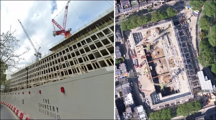
The title register and title plan for 24 to 31 Grosvenor Square in London show that the leaseholder is "Grosvenor West End Properties" which holds a 185 year lease from "Grosvenor (Mayfair) Estate" but no copy of the lease is held by the Land Registry. The charges section of the title register also mentions deeds made with two other companies: 30 GS Nominee 1 Limited and 30 GS Nominee 2 Limited - two of at least six "GS Nominees" registered with Companies House. The trail of "Grosvenor" companies and tax avoidance trusts, in the UK and in tax havens, would occupy an investigative journalist for quite a while.
This property, the old US embassy, is currently being developed as The Chancery Rosewood hotel by the Rosewood Group in partnership with the Qatar Investment Authority.
None of this latest development is reflected in the data held at the Land Registry even though the construction work began in 2021 - it was only discovered by doing a Steetview of the propertyt!
"Grosvenor" is the family name of the Duke of Westminster whose ancestors acquired large estates in England after killing people at Hastings at the beginning of the Norman occupation. Hugh Richard Louis Grosvenor, the current Duke, did not have to kill anyone - he acquired the £9bn estate (tax free) through the effort of being born.
Open and transparent
Data held by Companies House is public and available online free of charge.
Data held by the Land Registry is public but there is a charge of £7 for each title register and £11 for each title plan accessed online. Some title plans have to be ordered by post. This makes research slow and expensive.
Companies House allows reverse searches. Having found that person X is a director of company Y you can find which other companies X is also a director of.
The Land Registry does not offer a reverse search. You can find who is the freeholder of specific land but you cannot find which other land the freeholder holds.
Both organisations are trying to address serious problems with the validity of the data they hold. Both need to make significant improvements to their search functions.
Both organisations try to be "cost neutral" using charges to pay for the cost of their services. Companies House manages to do this without charging for online queries - the Land Registry should do the same.
Free access to data is essential in an open and transparent society. It also provides an external way of validating data. For example, someone failing to register a second home, or a holiday let, to avoid LVT supplements, would be picked up by locals making queries.
Cadastral maps
A cadastral map shows boundaries usually for the purpose of extracting rent or taxes. William of Normandy would have added one to the Doomsday Book in 1086 if modern mapping had been around at the time.
The Christian church has always extracted taxes (called “tithes”) from those who worked the land - usually set at 10% of the value of everything produced on the land. In the 19th century the Church of England published tithe maps to show landholdings down to field level. The example below is from 1839 is for the parish of Trusley in South Derbyshire. Click for a larger version.

Each tithe map was accompanied by an "apportionment" - a list showing landholders, tenants and the amount due to the church for each field - down to the nearest farthing - 1/960 of a pound! Click here for the Trusley apportionment listed in map reference order. (Other orders are available).
For light relief you may be interested in the act of parliament relating to the tithing of turnips!
At the beginning of the Norman occupation, William Duke of Normandy granted huge areas of land to the church so it could benefit from the labour of those who worked the land. The church was also given the right to a "tithe" on all land - 10% of everything produced - crops and animals. Not surprisingly, the church became very rich, especially as landholders were happy to leave land to the church on their death in order to buy their way into heaven.
During the dissolution of the monasteries Henry VIII took back the freeholds of church land and sold them to line his own pockets and to pay for wars with France.
The Land Registry releases data that enables third parties to produces cadastral maps (click here for an example) but it does not produce one which allows immediate access to freeholder data.
If the CofE could do it in 1839, and other countries can do it now (and make it freely available), why can't the Land Registry do it?